Open data program
Time-series SAR data. Updated frequently. Over $4 million of free data. No sign ups required.
About the program
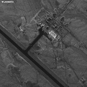
Umbra satellites offer the highest commercially available SAR imagery, surpassing 25 cm resolution. Capable of capturing images day or night, through clouds, smoke, and rain, our technology enables all-weather monitoring.
The Open Data Program monitors 20+ global locations, leveraging SAR’s unique capabilities for change monitoring. Explore our data to track floating oil lid inventory, deforestation, mines, container ports, and beyond.

Multiple time-series locations
The dataset features over twenty diverse locations to experiment with SAR’s capabilities. The number of locations will continue expanding throughout the year.
Time-Series Applications
With frequent updates of each location weekly, our goal is to provide you with a deep understanding on what’s possible with our data.
Spotlight Mode Data
Offering single-looked spotlight data in either 25cm, 35cm, 50cm, or 1m resolution, as well as multi-looked spotlight data.
Assorted Collections
Over 1000+ locations imaged, ranging from emergency response, ports, to picturesque places.
Licensing
All data is provided with a Creative Commons License, which gives you the right to do just about anything you want with it.
Jump into the Open Data Program
Over $4 million of free data. No sign ups required